
The Lower Olentangy Urban Arboretum (LOUA)
An arboretum is a “garden of trees” – to study, to build a sustainable environment, and to enjoy.
The Lower Olentangy Urban Arboretum is located in historic Clintonville on the north side of Columbus, Ohio. It is bounded by the Olentangy River on the west, Glen Echo Ravine on the south, Walhalla Ravine on the north, and the CSX Railroad tracks on the east.
Over the last decade, hundreds of native trees and shrubs have been planted on tree lawns throughout the Arboretum area, and select trees are marked along two tree walks (see maps below).
The ultimate goal is to grow a diverse, dense canopy of native species, connecting the ecological spaces along the Olentangy River and Glen Echo and Walhalla Ravines.
Lower Olentangy Urban Arboretum Walk Maps
Printed maps can usually be found at the Arboretum kiosk, located by the Indianola Informal K-8 School parking lot, across from the School, at 251 East Weber Road, Columbus, OH 43202. Sometimes we run out of maps – let us know (jbkrygier@owu.edu) and we can print more, or you can print your own from the maps below.
The maps can be printed full size on legal-sized paper (8.5″ x 14″) at Office Max, Staples, FedEx/Kinkos, etc. Save the map on a flash drive. You can also print the maps on regular-sized paper at home, but they will need to be resized in order to print the entire map on standard paper (8.5 x 11).
In some cases, the markers may be damaged or missing. Let us know.
New maps with updated data points are currently being made and will be uploaded by early April 2024.
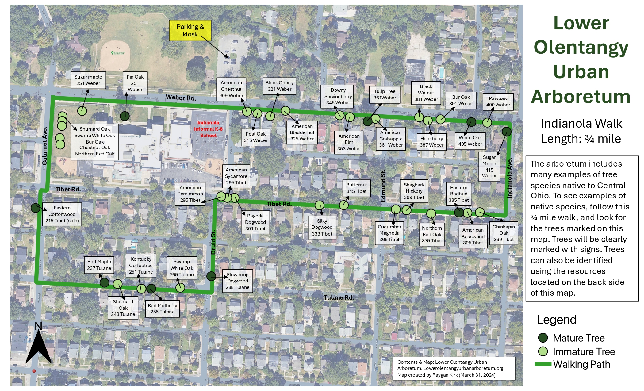
Indianola Walk Map: 3/4 mile walk. Updated April 15, 2024:

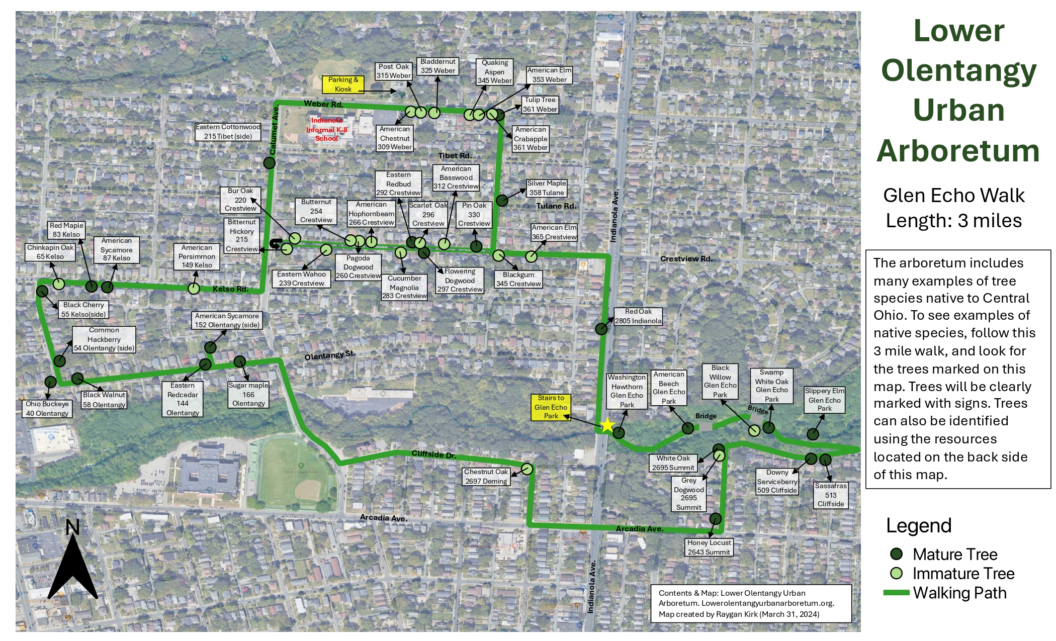
Glen Echo Walk Map: 3-mile walk. Updated April 15, 2024:

•••••
Boundaries of Lower Olentangy Urban Arboretum
Click here to view an online interactive map of all trees planted by LOUA!

…
Benefits of the Lower Olentangy Urban Arboretum
- Enhanced social and ecological neighborhood
- Encourage collaboration among neighbors to develop the arboretum
- Encourage field study of trees by students in local K-12 schools and universities
- Reduce storm run-off into the Glen Echo and Walhalla Ravines
- Reduce storm run-off onto streets and into the City of Columbus sewer system
- Connect the ravines via a tree canopy to benefit wildlife
- Reduce home heating and cooling costs (save 15% to 35% on energy bills)
- Traffic calming: 3 to 15 mph speed reduction anticipated on residential streets
- Reduce tailpipe emissions: street trees absorb 9 times more pollutants than distant trees
- Increased tax base – home values increase on tree-lined street 12 cents on the dollar
- Longer pavement life: 40 to 60% more life to asphalt. Decreases the daily heating and cooling (expansion/contraction)


Hi Robert, At this point most of Walhalla Ravine and north are outside of the Urban Arboretum. Current boundaries are on the Google map above. There has been talk of expanding the Arboretum northward and you can contact the current chair of the Arboretum, Andrew Heckler, for more information (heckler.6@osu.edu).
John K.
You should have a route that goes through Walhalla Ravine (and up along California & Pacemont on other side). This area has quite a few native & non-native trees of large size that aren’t on your other routes, and would also offer a quieter route.
Pingback: Tree Map Mashup and Other Updates | Lower Olentangy Urban Arboretum